Apollo 16: Major Photographic Inconsistency
Apollo 16: Major Photographic Inconsistency
The time interval between photos AS16-118-18888 and 18889
does not coincide with the time interval of the Earth’s rotation
Luis E. Bilbao, PhD
Following on from the analysis of the audio from Apollo 16, the author examines images of Earth purporting to have been taken during Apollo 16 on April 4 through April 27, 1972. As with the audio for this mission serious discrepancies have been found that are not explained by the official record.
 NASA 1969
Introduction
The Apollo 16 Image Library website includes, among other resources, a set of thumbnail images from magazine 118/NN (Color–Earth Orbit, Translunar Coast, Lunar Orbit, Frames 18857–19022).1 Within this collection, there is a sequence of six photographs: AS16-118-18885 and AS16-118-18887 through AS16-118-18891 – showing Earth progressively decreasing in size, as expected as the spacecraft moves away from the planet (see details in Fig 1 below).

Fig 1. Apollo 16, detail of the thumbnail set from the magazine AS 118/NN.
This sequence is also available in a low-res scan on the Lunar and Planetary Institute (LPI) website2(Fig.2).

Fig 2. Apollo 16, low-resolution photographs from the Lunar and Planetary Institute.
Also available in higher resolution versions on the Apollo 16 Image Library website3 (Fig 3).

Fig 3. Apollo 16 hi-res images from the Apollo 16 Image Library.
It is worth noting that compared to the other two sources, the images seen in Fig 3, from the Apollo 16 Image Library, are rotated such that the terminator appears on the right of frame and north is oriented upward – though not perfectly vertical, as will be discussed later. Additionally, photographs AS16-118-18890 and AS16-118-18891 are relatively enlarged compared to those shown in the other sources. A quick analysis shows they are magnified by a factor of 2. Surprisingly, these discrepancies are not mentioned in the Image Library. All photographs from a given magazine are expected to be scanned under identical conditions to ensure an accurate representation of the originals. If any adjustments are made to specific images, they should be clearly documented to prevent misinterpretations. Although in this case, the modification is relatively easy to detect, the absence of such warnings raises concerns about the reliability of the entire dataset.
Apart from the aforementioned rotation and the factor-of-two enlargement in two of the photographs from the Image Library, it is reasonable to assume that no other magnifications or reductions have been applied. Such modifications would be highly unlikely to occur identically across all three scans.
Therefore, after correcting AS16-118-18890 and 18891 in the Image Library by reducing them by a factor of two, we can conclude that the scans provide a faithful reproduction of the originals, as the sequence of Earth’s apparent size remains consistent across all three sources.
Analysis
By measuring the Earth’s radius in the photographs and considering the camera’s specifications, it is possible to determine the distance at which these photographs were taken using equation (10) in Appendix 1.
According to the mission’s technical data, the Hasselblad camera used in the command module was equipped with two lenses: one with a focal length of 80mm and another with a focal length of 250mm. To identify which lens was used for this sequence, we can compare the distances calculated from equation (10) in Appendix 1 for each lens.
Table 1 presents the possible distances for the six photographs mentioned above. Notably, the values obtained for the thumbnails, low-resolution images, and high-resolution images all align.
There is no doubt that the last two photographs were taken with the 80mm lens (as using the 250mm lens would have required them to be taken from distances far beyond the Moon). This implies that AS16-118-18889 was also captured with the 80 mm lens, because if it had been taken with the 250mm lens, its calculated distance would be greater than that of the next photo in chronological order, AS16-118-18890. This scenario is impossible, as the spacecraft did not move backward on its journey to the Moon.

Table 1. Distance to Earth’s surface from spacecraft according to the focal length of the camera lens used.
The same reasoning applies to the rest of the sequence. In conclusion, all six photographs were taken with the 80mm lens, and the distances corresponds to those listed in the first column of Table 1.
Although the Apollo 16 Flight Journal4 does not always specify the exact time at which each photograph was taken, it provides sufficient information to determine the spacecraft’s position versus time, so, from the distances in Table 1, we can calculate the instant at which the photos were taken. This information is summarized in Table 2.

Table 2: Distance to the Earth’s surface in kilometers and the instant at which the photo was taken with the 80mm lens.
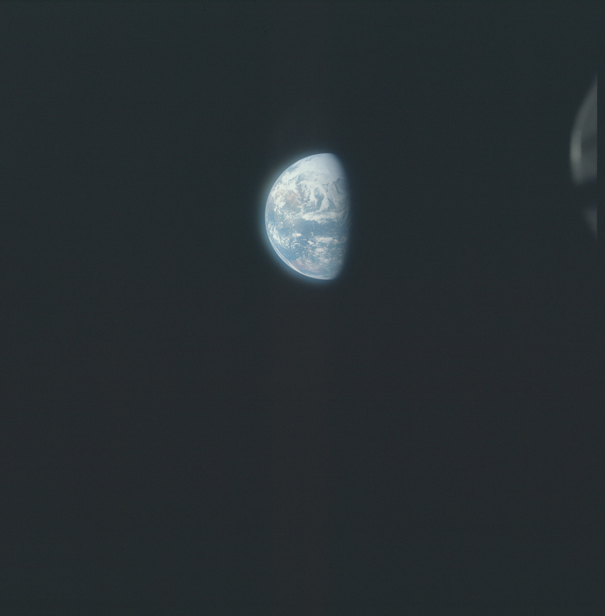
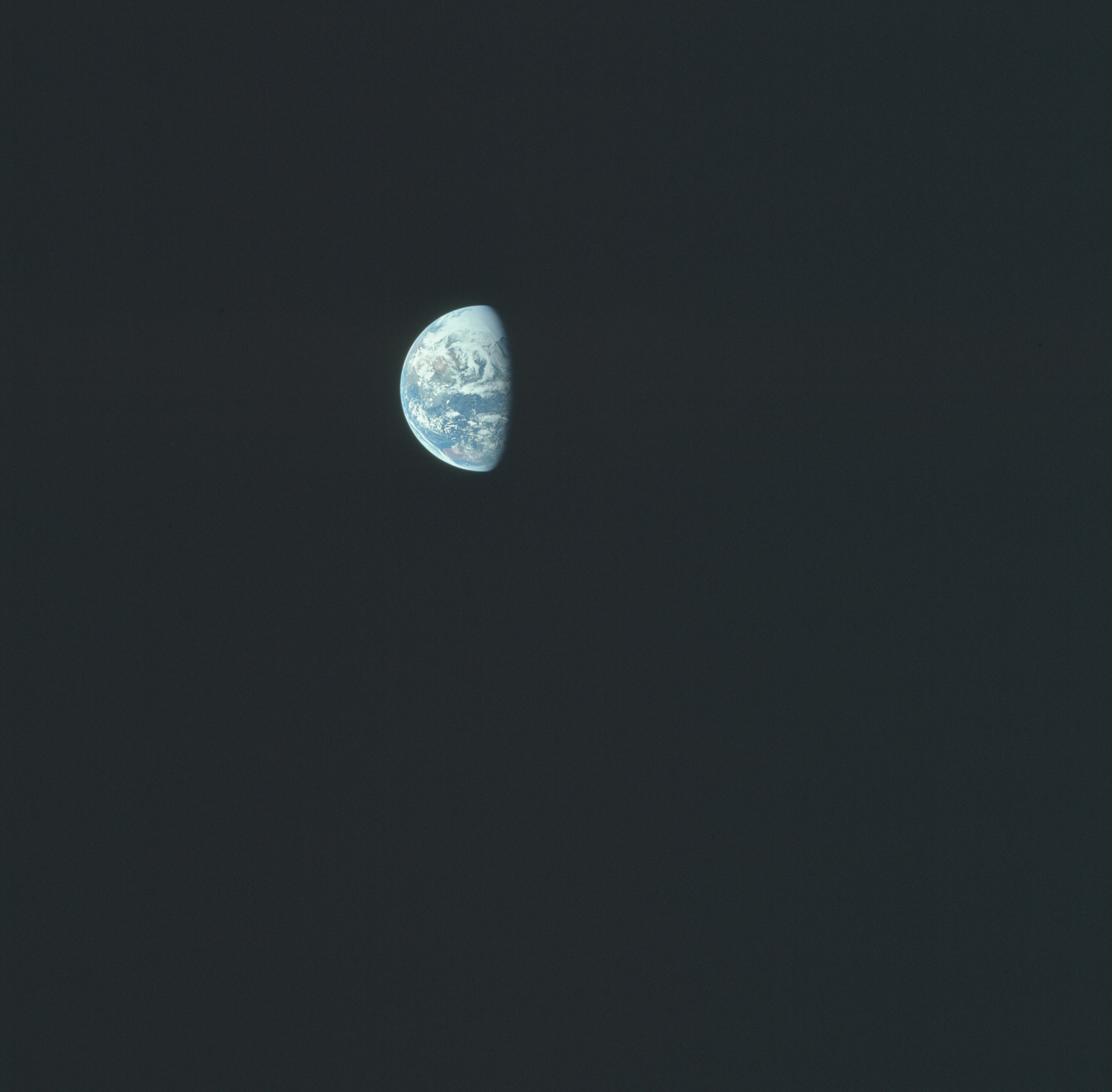
In particular, it can be seen that photographs AS16-118-18888 and 18889 were taken approximately 4 hours and 34,500km apart. However, this is inconsistent with the rotation of the Earth as seen in the higher resolution images in the Apollo 16 Image Library. A comparison between AS16-118-18888 and 18889 is shown in Fig. 4. The images have been scaled so that Earth appears the same size in both, facilitating direct comparison.
While these two photographs are very similar, they are not identical, ruling out the possibility of an error caused by duplicating the same image at different magnifications.

Fig 4. Apollo 16, detail of the Earth, left, photograph AS-118-18888, and right, AS-118-18889. The yellow semi-circle fits the circumference, the green semi-ellipse fits the terminator, whose semi-axes inform the angle of the direction of the solar rays and the direction of observation.
Australia is visible at the bottom of both images, with Asia at the top. The cloud patterns are nearly identical in both photographs, suggesting that only a short time elapsed between them – likely no more than an hour, see animation in Fig 5. A more precise estimate of the time interval can be obtained by measuring the displacement of visible land features relative to the terminator.

Fig 5. Apollo 16, animation between AS-118-18888 and AS-118-18889 showing the rotation angle between the moments they were taken.
As is demonstrated in Appendix 2, the terminator can be mathematically represented by an ellipse, where the major semi-axis corresponds to Earth’s radius and the minor semi-axis depends on the angle θ between the direction of the Sun’s rays and the observer’s line of sight (see equation (12) in Appendix 2). By fitting one half of Earth’s visible profile to a semicircle (yellow circle in Fig.4) and the other to a semi-ellipse (green ellipse in Fig 4), the semi-axis values can be determined in pixel units. Since the calculation of θ relies only on their ratio, there is no need to convert them to kilometers or another unit. The results indicate that θ ≃ 68.5º in both images, within a small margin of error. This suggests that the direction of observation relative to the Sun’s rays remained constant between the two photographs, implying that the spacecraft followed a nearly straight trajectory.

Fig 6. Apollo 16, detail of the Earth, left, AS-118-18888, and right, AS-118-18889. The magenta dotted line is the axis of rotation of the Earth, the red circle indicates the northwest Cape of Australia, and the red dotted ellipse is the meridian corresponding to this point.
Additionally, we can infer the orientation of Earth’s rotational axis by analyzing the movement of visible land features and global cloud patterns relative to the observer’s line of sight. This is illustrated in Fig 6 by a magenta dash-dot line. Knowing that these photographs were taken between the spring equinox and the summer solstice (in the Northern Hemisphere), the inclination of the Earth’s axis toward the Sun is approximately as expected. The land features shifted very little between the two images. Taking, for instance, North West Cape in Australia (marked by a red circle in Fig 6) as a reference, we can draw its corresponding meridian as a semi-ellipse (red dotted semi-ellipse in the figure). The angle φ between this meridian and the observer’s line of sight is obtained using equation (11) from Appendix 2.
For AS16-118-18888, we find ϕ ≃ 63.2º, while for AS16-118-18889, ϕ ≃ 54.6º. This indicates a shift of only 8.6º between the two images relative to the observer’s view (or, equivalently, relative to the terminator). This corresponds to a time interval of approximately 35 minutes – consistent with the minimal deformation observed in the cloud structures, but this is totally incompatible with the 4-hour difference obtained from the size of the Earth in the photographs.
In 4 hours the Earth would have had to rotate about 60º (during which Australia would have been practically entirely in darkness) instead of the meager 9º observed in the photographs. On the other hand, in 35 minutes the craft could not have travelled 34,500 km, which is the distance separating both photos, since this would represent an average speed of 16.4 km/s – much higher than the escape velocity at that distance from Earth, which is less than 3 km/s.
Note. Apollo Mission Control in Houston was supplying the Apollo 16 crew with their distance from Earth in nautical miles and their velocity data in imperial feet per second. The Apollo Lunar Surface Journal has added [kilometers] to the transcripts. That 3km/s corresponds to 9,842 ft/s.
Conclusions
By measuring the Earth’s radius in the photographs, the distance at which they were taken have been calculated. In turn, by knowing the craft’s ephemeris, the photographs can be placed chronologically. By doing this analysis, it is found that the time interval between photographs AS16-118-18888 and AS16-118-18889 obtained with this method does not coincide with the time interval given by the Earth’s rotation observed in these photographs.
In summary: On the one hand, it must be accepted that the difference in the size of Earth in AS16-118-18888 and AS16-118-18889 is due a 4-hour journey of 34,500 km distance. While, on the other hand, according to the rotation of the Earth, only 35 minutes have elapsed between these two photographs.
Since these two premises cannot be simultaneously true, it implies that at least one photograph is false, but since they all belong to the same magazine, it leads to the inevitable conclusion that that they must all be false, since it would be both absurd and impossible to intersperse false/fake photos with real photographs.
Luis E. Bilbao
Aulis Online, April 2025
See also Editor's Notes below
About the Author
Luis Ernesto Bilbao has a PhD in Physics from the University of Buenos Aires, is Adjunct Professor, and Independent Researcher, INFIP CONICET, UBA (the Faculty of Exact and Natural Sciences, University of Buenos Aires, Argentina).
The Institute of Plasma Physics (INFIP), dependent on the CONICET and the FCEyN-UBA, is a center carrying out pure and applied research in a wide variety of subjects of this discipline. The INFIP researchers have extensive knowledge and many years of experience in this branch of physics, with the publication of more than 600 works since 1983.
References
1. https://www.nasa.gov/wp-content/uploads/static/history/alsj/a16/Ap16_Mag118.jpg retrieved January 2025.
2. https://www.lpi.usra.edu/resources/apollo/catalog/70mm/magazine/?118, retrieved January 2025
3. https://www.nasa.gov/history/alsj/a16/images16.html#M118, retrieved January 2025
4. https://www.nasa.gov/history/afj/ap16fj/index.html, retrieved January 2025
5 https://www.nasa.gov/wp-content/uploads/static/history/alsj/a16/as16-118-18888.jpg
6. https://www.nasa.gov/wp-content/uploads/static/history/alsj/a16/as16-118-18889.jpg
Editor’s Notes
Luis Bilbao has evaluated his data using the SI system as used by Houston in all their calculations. However, the NASA Apollo Mission Reports explicitly state that the distances between Earth and Moon were expressed as Nautical Miles, even when written as ‘miles’ in these particular reports.
The audio transcripts recording the conversations between the astronauts and the ground only used terms familiar to the American public of the ’60s and ’70s. These also expressed distance as Nautical Miles. Luis Bilbao was therefore somewhat surprised to see published on the Apollo Lunar Surface Journal (ALSJ), a very odd dialogue within the Apollo 11 audio stream.
Firstly, setting the context, the PAO had announced the beginning of the TV transmission:
PAO: [Public Affairs Officer speaking from Houston] This is Apollo Control at 55 hours, 10 minutes. Our network controllers just advised that we are receiving live television at Goldstone. We would presume this is a test of the system, similar to what we received from the crew yesterday. The crew is planning to send television from the Lunar Module when they ingress. Stand by – here's a call to the crew.
At somewhere between 055:10:17 and 055:19:49 the PAO announced:
This extremely sharp, clear picture is coming to us from about 175,000 miles distance from Earth. Presently about 48,000 miles from the Moon.
Here we have only an estimated distance and nautical miles are not specifically stated by the PAO.
Then comes the section that alerted Luis Bilbao. The dialogue is reproduced here,1 without the [km and NM insertions] made by the ALSJ editors:
Apollo 11, Day 3, part 2: Entering Eagle.
056:40:47 Aldrin: How far are - out are we now, Charlie?
056:40:51 Duke: Stand by. Give you an exact figure. [pause]
056:41:00 Aldrin: Did you notice the difference between yesterday and today? This is as large an image as we - as we can give you.
056:41:05 Duke: Roger. It's distinctly smaller. You're now 177,000 miles out. Over.
056:41:13 Aldrin: Thank you.
056:41:14 Armstrong: That's nautical miles?
056:41:17 Duke: That's affirmative.11. We…
Note the fact that we now get an exact distance but not the measurement system in use. Checking the ALSJ audio both backwards and forwards, the PAO had stopped using the term nautical miles just before the TV session, when the Apollo 11 was stated to be some 173,997 nautical miles from Earth. He resumed using the term nautical miles a mere 18 seconds after the end of the TV transmission.
So it would appear that Armstrong, knowing perfectly well that all distances are in nautical miles, is specifically drawing attention to this particular segment of the mission. During the period in which these images of Earth were allegedly taken, the official record is imprecise as to exactly from where that might be. Even more surprising is the very next query when, according to the ALSJ, six seconds later Mike Collins ignores Duke’s preceding answer and asks:
056: 41:23 Collins: That in furlongs?
056: 41:24 Duke: Go ahead. Over.
Duke in turn ignores Collins’ query. It was necessary to return to the original audio recorded by NASA,2 to find out to whom Duke is speaking when he says ‘Go ahead over’. From that, we find out that Mike Collins is speaking to Armstrong but the link to CapCom is still open! There are also significant alterations between the original audio and the ALSJ version, when discussing the relative size of Earth. The original transcript goes like this:
SC [Spacecraft] How far out are we now, Charlie?
CAPCOM Stand by. Give you exact figure.
SC If you notice the difference between yesterday’ [s] and today. This is large in everything as we continue.
CAPCOM Roger. If you think we're smaller, your [sic] now 177,000 miles out. Over.
SC All right. That's nautical miles?
CAPCOM That's affirmative.
CAPCOM 11. We –
SC I'm still on.
CAPCOM Go ahead. Over.
It would seem that while the furlong query was cut out from the original copy, the ALSJ editors have inadvertently restored it without realising its importance. After all, furlongs have nothing whatsoever to do with any system being used during this Apollo mission.
Originally, during the 1300s, the furlong defined the length of a furrow that could be ploughed before the cattle or horse needed a rest. In 1593 during the reign of Elizabeth I of England, the mile was established at 5280 ft, and the furlong was defined as 1/8th of that mile. Today the furlong is used in horse racing, where a series of furlong markers line the track. Placed every 660 ft, (220 yards), these advise the jockey as to how many the furlongs remain before the finishing post is reached.
Whether that open mike was unintended is a moot point, because Collin’s query about furlongs is a major anomaly – or a whistle blow. Collins’ intervention could be a nod to the myth of Phoebus Apollo driving the four horses that daily pulled the chariot of the Sun across the sky, or even associated with the chariot racing practiced by the Greeks and the Romans, but this was surely not the time nor the place for such a remark.
Unless it was truly intended as it sounded: taking his question as a literal statement, 177,000 furlongs denotes a distance of 22,125 miles from Earth. The orbital path of Geostationary satellites, which these days is also known as the Clarke Belt.3 Interestingly, the conversation which follows that furlong query would seem to insist on that region – this from the ALSJ:
056: 41:34 Duke: 11, Houston. We see the – still see the banding along the inter-tropical convergence. I guess the most predominate one now is around the up in the – around the equator or slightly north of the equator.
056:41:51 Aldrin: Yeah, that's the way it looks, Charlie. Same as yesterday.
056:41:54 Duke: Rog. [Long pause.]
056:42:05 Aldrin: Just keep the Pacific Ocean nice and clear and calm on splash day. That's all we ask. [Long pause.]
This view of the Pacific Ocean would figure prominently on other Apollo mission's images of Earth, as discussed by another physicist Phil Kouts.4
At the time of Apollo, the public trusted in the data supplied by NASA. However, with the benefit of better technology in the public domain, it is possible to conclude that the images of Earth ascribed to the Apollo program were taken in low-Earth orbit, as well as from geosynchronous orbit, thereafter manipulated to produce the appropriate effects for each mission.
It is only because nautical miles were not mentioned during the image transmission that both Armstrong and then Collins were able to ask their questions, and a careful study of the audio record strongly infers that those involved made every effort to both distance themselves from official scrutiny, while highlighting the deception and placing it on the official record.
As did those who were writing the computer programs.5 All these efforts were carefully hidden from their own agencies, not least because in order to decode these particular messages, one needed to know the history, not of the USA, but of England. The rebellion of Jack Cade, triggered by the corruption of the authorities of his time, at the heart of which was the Duke of Suffolk, lasted from April-July 1450. Apollo 16 flew in April 1972, one of their CapComs was also called England. Apollo 11 flew in July 1969, one of their CapComs was also called Duke,6 later he would become the Lunar Module pilot on Apollo 16.
Luis Bilbao has brought us full circle.
M, Bennett, April 2025
Editor's Note References
1. ALSJ, the Apollo 11 Journal was established in 1995 and its last revision was 26 March 2019. NASA historian Eric M Jones claims copyright to all corrected transcript and commentary, however the transcripts derive from NASA and are in the public domain. https://www.nasa.gov/history/alsj/a11/a11.html
2. The original 1969 audio between the Apollo 11 spacecraft and ground control is a11transcript_pao.pdf. This PDF of 478 pages has a purple edged cover showing the bootprint image. The relevant dialogue is on pp145-146. This PDF is tricky to upload, without getting snared by the ALSJ version or a blank NASA ‘400page’.
 At the time of publication, April 2025, this document is listed as Apollo 11 Spacecraft Commentary https://www.nasa.gov/wp-content/uploads/static/history/alsj//a11/a11transcript_pao.pdf
3. Sir Arthur C. Clarke had first proposed the establishment of this geosynchronous satellite communications belt back in the 1940s. Clarke says he was in part inspired by 13 stories written by George O Smith concerning a communications hub positioned at the L4 Lagrange point of the Sun-Venus system. From 1942-45 these appeared in the Sci-Fi magazine Astounding Stories, edited by Joseph Campbell. Decades later, in 1976 they were collected into a book titled Venus Equilateral after the name of the fictitious L4 station, and Clarke contributed a foreword. The passage of Venus across the Sun is also associated with the number 8, as was the first Apollo mission to be scheduled to take a photo of the Earth from space.
4. Phil Kouts from his 2019 study of Apollo 17: ”It is obvious that there were a number of impressive options for taking pictures with the Earth. For example, at the end of the first EVA the continents of Asia and Australia would have been in view, while in the beginning of the third EVA, California was visible. Nevertheless, the photos of the Earth in the Apollo 17 mission were taken only when the Moon was exactly over the Earth’s equator with 150º West longitude in the middle of the Pacific...”
Phil Kouts has carried out three analyses of the images of Earth/Moon linked to the Apollo missions: https://www.aulis.com/moon-earth.htm, 2008 and Part 2
https://www.aulis.com/moon-earth_afterword.htm, 2014
https://www.aulis.com/moon-earth3.htm, 2019.
5. Bilbao, Luis E, A Significant Moment for Apollo 16
6. Crew & CapCom Information https://www.nasa.gov/history/alsj/crew.html
This article is licensed under
a Creative Commons License
AULIS Online – Different Thinking